Saturday, August 26, 2017

The Breadloaf Wilderness


The portion of Vermont's Long Trail between Lincoln Gap and Middlebury Gap (VT-125) lies within the Breadloaf Wilderness. The Long Trail Guide says that in federally designated wilderness areas:

You will find that signs are less frequent and often omit mileage figures, trail blazing and brush cutting are limited, bridges, if any, are generally primitive, and there are occasional stream fords.

Nancy and I hiked this section of the Long Trail yesterday. We did not encounter any stream fords. Nor did we encounter many people – only 11 or 12 people all day, in ones and twos, all headed northbound. We hiked southbound from Lincoln Gap to Middlebury Gap. The photo above is Nancy signing in at the beginning of our hike in Lincoln Gap at 6:10 AM. The sign at the right says "Breadloaf Wilderness / Green Mountain National Forest."

This portion of the Long Trail is sometimes called Vermont's Presidential Range because it includes Mounts Grant, Cleveland, Roosevelt and Wilson. At 3400 to 3800 feet, the summits are much lower than New Hampshire's famous Presidential Range, and there are few views. Not even the highest elevation on our hike yesterday, Breadloaf Mountain at 3835 feet, had a view. One of the few places on our hike with a view was Killington View, shown below:


We hiked by four shelters yesterday:
This photo shows Skyline Lodge:


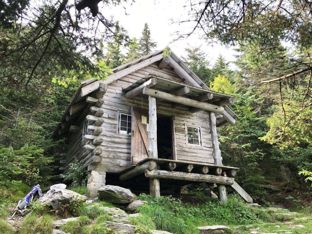
Skyline Lodge overlooks Skylight Pond, which is the headwater of the White River:


Near the end of our hike was a 0.4 mile side trail out to Silent Cliff where we understand there is a beautiful vista. We left that for another day. The photo below shows Nancy at the end of our hike in Middlebury Gap at 6:50 PM:


The sign at the left says "Breadloaf Wilderness / Green Mountain National Forest."

We were on the trail for nearly 13 hours. It was a good day for hiking, with no bugs, temps in the upper 50s and low 60s, no rain, mostly cloudy, not too muddy. Mileage was 17.3 miles on the Long Trail plus 0.1 mile each way to Skyline Lodge for a total of 17.5 miles. My Fitbit registered 55,036 steps for the day. Nancy's registered 53,136. We may never break those records.

Saturday, August 12, 2017

The Inn at Long Trail

After completing our hike on the Long Trail to US-4, Nancy and I stayed overnight at the Inn at Long Trail in Killington, Vermont:


Live Irish music in McGrath's Irish Pub, Guinness on tap, a delicious dinner, and a shower and bed sure beat a two hour drive home after 15 miles on the trail. We did not stay up long.

Nor did we, on this trip, hike to the top of the cliff in the photo above. That is Deer Leap Mountain. I understand the views are spectacular, but it is not on the Long Trail and therefore it was not on our itinerary for this trip. Another time.

At breakfast this morning, I was interested to read the history of the Inn at Long Trail and McGrath's Irish Pub:


It's a storied history beginning in 1923, even making the New York Times at one point. (Click on the image to enlarge.) The last sentence reads:

In July 1977 Kyran and Rosemary McGrath purchased the lodge renaming it "The Inn at Long Trail", and created "McGrath's Irish Pub", the first in Vermont to serve Guinness on draft.

The first sentence is also interesting:

The Long Trail Lodge [the original name] itself was conceived by Mortimer R. Proctor as a clubhouse for the Green Mountain Club.

My sister Beth and I recently mentioned Mortimer Proctor in our history of Cloverdale presentation that we did together for the Cambridge and Westford Historical Societies. We grew up in the 1950s and 1960s on the Putnam Farm at one end of the Cloverdale neighborhood. Mortimer Proctor's mother, Minnie Robinson Proctor, grew up in the 1860s and 1870s on the Cloverdale Farm at the other end of the Cloverdale neighborhood. Why was this noteworthy? Mortimer's grandfather, father, uncle, and Mortimer Robinson Proctor himself were all governors of Vermont. We said in our presentation: "Cloverdale was always proud of its own First Lady of Vermont."

Friday, August 11, 2017

Long Trail to US-4

Today Nancy and I hiked the Long Trail from David Logan Shelter to US-4 (southbound). The photo below is about 2/3 of the way through our hike at Rolston Rest Shelter:


Vermont's Long Trail is the oldest long-distance hiking trail in the United States, dating from 1910. This 270-mile long hiking trail runs along the spine of the Green Mountains in Vermont from Massachusetts to Canada. The Long Trail (LT) inspired Benton MacKaye to propose the idea of the Appalachian Trail (AT) in 1921. The AT eventually became a 2,100-mile long hiking trail from Springer Mountain in Georgia to Mount Katahdin in Maine.

The AT and the LT coincide in southern Vermont, parting ways at "Maine Junction" in Willard Gap (see photo below). Maine Junction was on our hike today, toward the end, just north of US-4. From here, the AT heads east to New Hampshire and Maine, while the LT continues north to Canada.


Our hike took us to the east of Chittenden Reservoir, which we occasionally glimpsed through the trees (alas no good photos of the reservoir). This portion of the Long Trail crosses both public and private land. Vermont prides itself on having a "working landscape" as noted in this sign that we saw on a downed tree:


The three logos on the sign above are of the Green Mountain Club, the United States Forest Service (USFS), and the Vermont Department of Forests, Parks and Recreation. The Green Mountain Club maintains the Long Trail in partnership with the respective federal and state agencies.

We saw moose droppings and moose tracks (see photo below next to Nancy's boot), but no moose. However, we did find some blackberries to pick and eat.


The photo below shows where we came out on US-4, looking back (north) at where we had come from. The sign says: "Long/Appalachian Trail North."


Today's hike was easy walking compared to the rugged terrain on portions of our hike last month. We parked one car at the end of USFS Road 99 in Chittenden and hiked in to the David Logan Shelter on the New Boston Trail. We parked a second car at the Inn at Long Trail on US-4 in Killington. Total distance was 14.7 miles: 1.2 miles on the New Boston Trail, 12.7 miles on the LT, and 0.8 miles on US-4. My Fitbit registered 44,161 steps. Nancy's registered 40,673. Neither of us used hiking poles on this hike.