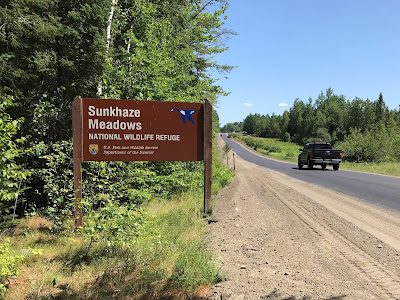
Sunkhaze Meadows National Wildlife Refuge is located in Milford, Maine, about 15 miles northeast of Bangor. Nancy and I had not heard of it before this year.
The NWR consists of more than 11,000 acres that include the second largest peat bog in Maine. There were plans in the early 1980s to mine the peat deposits, which reach depths of 15 feet or more, but the U.S. Fish & Wildlife Service acquired the property in 1988 and protected it.
In addition to the peatland complex of several raised peat domes, the NWR includes wetlands and uplands with a wide variety of plants and animals. More than 200 species of birds have been identified in the forests and swamps. Larger mammals found in the refuge include beaver, muskrat, otter, mink, moose, white-tailed deer, black bear, coyote, fisher, snowshoe hare, and porcupine.
The U.S. Fish & Wildlife Service website for Sunkhaze Meadows National Wildlife Refuge does not explain how to get there, so here are directions. From US-2 in Milford, turn east on County Road (0.0 miles). There is a large sign at about 4.1 miles (photo above). County Road becomes a dirt road at about 4.4 miles. The gated Carter Meadow Road is on the left at about 6.1 miles. Continue another 150 yards or so to the small parking lot at 6.2 miles (photo below).
There are few facilities in Sunkhaze Meadows. There is no visitor center. It is mostly a wild place. There are four small parking areas like the one described above. The best information about the refuge is on the signs and in the brochures at these parking areas. See below for the map from one of these brochures:
There are about 10 miles of semi-maintained trails accessible from three of the parking areas. The fourth parking area provides access to Ash Landing, a canoe/kayak launch on the northeastern side of the refuge. Sunkhaze Stream runs through the refuge from northeast to southwest for nearly five miles and empties into the Penobscot River west of the NWR.
From a brochure that we picked up at the refuge:
The name Sunkhaze is derived from the Abnaki phrase Wetchi-sam-kassek which, roughly translated, means "concealing outlet," referring to the stream's well disguised confluence with the Penobscot River.
McLaughlin Road runs through the western part of the refuge. This 2-mile gated dirt road is open to bicycles, motor vehicles during the fall hunting season, and snowmobiles in the winter.
The State of Maine lists Sunkhaze Meadows as one of its Focus Areas of Statewide Ecological Significance. See the Sunkhaze Meadows Factsheet (pdf).
Sunkhaze Meadows NWR includes three smaller satellite units located some distance away in other parts of Maine. This post is not about those units.


No comments:
Post a Comment