Saturday, September 23, 2017

Nancy Finishes the Long Trail


Nancy finished hiking the Long Trail today! The photo above is celebrating on the summit of Mount Abraham with family and friends.

Today's hike was from Appalachian Gap south to Lincoln Gap. The photo below is in App Gap at the beginning of the hike, just as the sun was rising:


Emily, Laura, Eliza and Dylan (and their dog Kona) hiked with us from App Gap. It was a beautiful day, with good views. Not much color in the fall foliage yet. This section of the Long Trail is along the top of a ridge with several ski areas on the east side – Mad River Glen, Sugarbush North, and Sugarbush South. Below is the famous single-chair ski lift at Mad River Glen Ski Area:


The photo below was the view from Sugarbush South Ski Area:


There are five 4000 foot peaks in Vermont, and we hiked over two of them today: Mount Ellen (4083') and Mount Abraham (4006'). Mount Ellen has a wooded summit, but the top of Mount Abraham is open. From the Long Trail Guide:

The alpine summit of Mt. Abraham offers one of the best panoramas on the entire LT, ranging from nearby valley farms to New Hampshire's White Mountains, 80 miles east. Due west is Mt. Marcy and its Adirondack neighbors. To the south the Green Mountains may be visible as far south as Killington Peak. To the north, though partly hidden by nearby higher peaks, the Greens may be visible as far as Belvidere Mtn.

We had a beautiful day, but we could not see as far as Belvidere Mountain. The other three 4000 foot peaks in Vermont are Mount Mansfield (4395'), Killington Peak (4235'), and Camels Hump (4083').

Howard, Sue, Bob, Joel, Bill and Donna (and their dog Moia) hiked in from Lincoln Gap and met us on Mount Abraham. The photo at the top of this post shows the whole crew on the summit of Mount Abraham.

Eliza packed cheese and crackers, as well as a cheese board and cheese knife, all the way from App Gap:


We celebrated Nancy's accomplishment in style! There might even have been some champagne and switchel consumed on top of Mount Abraham...

Below is Nancy at the end of the hike in Lincoln Gap:


Congratulations, Nancy!

Today's hike was 11.6 miles. We started at 7:05 AM and finished at 5:20 PM. (We lingered on the summit of Mount Abraham for an hour and 20 minutes.) Nancy's Fitbit registered 35,522 steps, mine registered 38,512.

Nancy is the fourth member of the family to complete the Long Trail. Howard and I and others hiked the LT with Boy Scouts in 1997-2001 (Bob and Joel were on some of those hikes). Laura hiked the LT with Eliza in 2006. Emily hiked the LT with a friend in 2009 (see Emily Hikes the Long Trail). Nancy supported all of those undertakings and hiked portions of the LT herself as part of each of those adventures, but her log of recorded LT hikes for her End to End Journal begins before any of those dates. Nancy's log begins with a short hike to Prospect Rock in 1988, the day before Emily was born.

Thursday, September 7, 2017

Who was Emily Proctor?


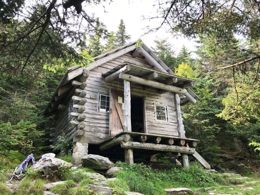
The Emily Proctor Shelter (photo above) is on Vermont's Long Trail in the middle of the Breadloaf Wilderness. The Emily Proctor Trail is a side trail that leads from USFS Road 201 to this shelter. Who was Emily Proctor?

I wrote about the Proctor family in my earlier post The Proctor Family. Three generations of the Proctor family led the Vermont Marble Company and provided four Vermont governors. Emily Proctor was part of this family. But which Emily Proctor? My earlier post about the Proctor family listed three Emily Proctors, one in each generation:

1st generation: Emily Proctor (1835-1915) was the wife of Redfield Proctor.

2nd generation: Emily Proctor (1869-1948) was the daughter of Redfield and Emily Proctor.

3rd generation: Emily Proctor (1887-1964) was the daughter of Fletcher and Minnie Proctor, and granddaughter of Redfield and Emily Proctor.

The Green Mountain Club (GMC) publishes a book titled Place Names on Vermont's Long Trail. This book says the following (1st edition, 2007):

Emily Proctor Shelter - This shelter, built in 1960 and rebuilt in 1983 and 2002, honors Emily Proctor, for whom a previous shelter was named early in GMC history. In 1914, she gave $500 to the GMC for the construction of three shelters.

Alas, that does not tell us which of the three Emily Proctors is being honored. All three of the Emily Proctors mentioned above were alive in 1914.

In my earlier post The Long Trail Lodge, I wrote about Mortimer Proctor (1889-1968) who was the son of Fletcher and Minnie Proctor and thus brother of Emily Proctor (1887-1964) in the third generation of Proctors. I mentioned that Mortimer Proctor was twice president of the Green Mountain Club, which built and maintains Vermont's Long Trail. But nothing in that post, either, tells us which Emily Proctor the shelter and trail are named for.

The Proctor family was "the GMC's wealthiest patrons" in the early years of the Green Mountain Club (source: On the Trail: A History of American Hiking by Silas Chamberlin (Yale University Press, 2016), page 119). In my earlier post The Long Trail Lodge, I explained how Mortimer Proctor and his mother gave the Long Trail Lodge in Sherburne Pass to the Green Mountain Club in 1923. But which Emily Proctor gave $500 for three shelters in 1914? Mortimer's grandmother, aunt, and sister were all named Emily Proctor!

Construction of the Long Trail began in 1910 and was completed in 1930. Mileage was added throughout that period. The book On the Trail notes that more than 50 miles of trail were added in 1913 between Camel's Hump and Killington Peak, and goes on to say:

With the additional mileage, the club began to construct log lean-tos that would provide temporary shelter for hikers. The first were built at Birch Glen, at Broad Loaf Glen [sic], and south of Mount Horrid with the private funds of Emily Dutton Proctor, the philanthropist daughter of Redfield Proctor, founder of the Vermont Marble Company and U.S. Senator from Vermont.

(Source: On the Trail, page 118. Should be Bread Loaf or Breadloaf not Broad Loaf.)

Bingo! Emily Dutton Proctor was the Emily Proctor (1869-1948) in the second generation of Proctors. She was Mortimer's aunt. She was a noted philanthropist – known, for example, for collecting foreign-language and picture books for the immigrant workers of the Vermont Marble Company and their children.

I wish to thank John Page, the current president of the Green Mountain Club, for solving this mystery for me by finding the above reference in On the Trail. John further wrote the following to me in an email:

The shelter "south of Mt. Horrid" that Emily Proctor also funded was the original Sunrise Shelter, just south of Brandon Gap. This shelter was replaced in the 1960's by the current Sunrise Shelter with funds donated by Mortimer Proctor. Thus the current Sunrise Shelter appears to be the last remnant of the Proctor family's GMC legacy other than the name of Emily Proctor Shelter.

Full disclosure: I am related to John Page, a cousin. John Page's aunt, Jane Clark Brown, and my father, Harold Putnam, co-authored a book in 2001 titled Cloverdale: An Anecdotal History of A Rural Neighborhood. My sister Beth and I used this book as the basis for a presentation in July for the Cambridge and Westford Historical Societies on the history of Cloverdale. Minnie Robinson Proctor, Mortimer's mother, grew up in Cloverdale. It's a small world.

The Long Trail Lodge

The Long Trail Lodge was built in Sherburne Pass in 1923 and served as a grand hotel on Vermont's Long Trail until it burned in 1968. By all accounts it was spectacular. The Long Trail Lodge also served as the headquarters of the Green Mountain Club, which built and maintains the Long Trail, the oldest long-distance hiking trail in the United States.

Today US-4 passes through Sherburne Pass in the town of Killington. The Inn at Long Trail sits on the north side of US-4 directly under Deer Leap Mountain and continues the hospitality tradition of the former Long Trail Lodge, which had been just across the road. See my earlier post about The Inn at Long Trail, where Nancy and I stayed last month after a long day-hike on the Long Trail. Nancy is finishing hiking the Long Trail this year, and all of the posts on this blog since July have been related to that project.

The Long Trail Lodge was built and donated to the Green Mountain Club by the Proctor family. I have become interested this summer in some of the history of this prominent Vermont family, especially Minnie Robinson from Cloverdale who married into the family in 1886. See my earlier post about The Proctor Family for background and who's who in the Proctor family.

Three generations of the Proctor family led the Vermont Marble Company and provided four Vermont governors. For this post, we are particularly interested in Minnie Robinson Proctor (1865-1928) who married Fletcher Proctor (1860-1911), and their son Mortimer Proctor (1889-1968). Both Fletcher and Mortimer were governors of Vermont, as were two other members of the Proctor family.

The idea of Vermont's Long Trail was conceived by James Taylor in 1909. The Green Mountain Club (GMC) was formed in 1910 to build the trail, completing the task in 1930.

Mortimer Proctor played a significant role in the early years of the GMC. The first four presidents of the GMC were:
  1. James P. Taylor 1910-1916
  2. Mortimer R. Proctor 1916-1917
  3. Charles P. Cooper 1917-1925
  4. Mortimer R. Proctor 1926-1933
Thus Mortimer Proctor was president when the Long Trail was completed in 1930, and he was the only person in the history of the GMC to have been its president twice.

The Proctor family was "the GMC's wealthiest patrons" in the early years of the club (source: On the Trail: A History of American Hiking by Silas Chamberlin (Yale University Press, 2016), page 119). When the growing GMC expressed the need for a clubhouse, Mortimer Proctor and his mother, Minnie Robinson Proctor, provided it:

In 1922 came the exciting news that a clubhouse was assured and would be built the next year at Sherburne Pass where the trail crossed the highway. President Mortimer Proctor telegraphed from Los Angeles to Acting-President Cooper, "I wish to donate complete the new Green Mountain Club House to be built near Deer Leap on Sherburne Pass." With his mother, Mrs. F. P. Proctor, he generously gave the land and money to build what was long considered to be the home of the Green Mountain Club.

(Source: Green Mountain Adventure, Vermont's LONG TRAIL, An Illustrated History, by Jane and Will Curtis and Frank Lieberman (The Green Mountain Club, 1985), page 39. Mortimer's father, Fletcher Proctor, had died in 1911.)

The Long Trail Lodge, built in 1923, was no ordinary back-country lodge:

The most agreeable example of rustic architecture on the trail is the Long Trail Lodge opposite Deer Leap in Sherburne Pass, the lodge being the gift of Mortimer R. Proctor and the furnishings the gift of [his mother] Mrs. Fletcher D. Proctor. These two lovers of Vermont, with the aid of Architect [Paul] Thayer, have done something exceptional not only in the appointment of the lodge itself but in the surroundings, and as it is at a junction of the Trail and a main automobile road, it can be more readily reached and seen than it can be described.

(Source: Footpath in the Wilderness edited by W. Storrs Lee (Middlebury College Press, 1941), pages 31-32.)

Visitors never forgot their amazement when they entered the lobby whose walls weren't wood and plaster but a huge fern-covered rock ledge down which trickled a miniature waterfall. The club was particularly pleased with the effect of the dining room. The architect had left bark on the yellow birch beams and had designed a great chandelier of ten lights made of white birchlimbs with shades of birch bark. ... The most astonishing feature of the Lodge was that the Long Trail went right through the building!

(Source: Green Mountain Adventure, pages 39-41.)

On September 12, 1931, a grand celebration was held at the Long Trail Lodge in recognition of the completion of the Long Trail the year before and the "coming of age" (21st birthday) of the GMC:

James Taylor called the lodge – the gift of club president and future governor Mortimer R. Proctor and his mother – the "finest mountain camp in the world." The festivity began with speeches by Governor Stanley C. Wilson, Dorothy Canfield Fisher, Will Monroe, Taylor, and others.

(Source: A Century in the Mountains: Celebrating Vermont's Long Trail edited by Tom Slayton (The Green Mountain Club, 2009), page 47.)

The Long Trail Lodge served as headquarters for the GMC for more than 30 years. It was also a grand hotel, but the GMC ultimately tired of the hospitality business and owning a property that was expensive to maintain. The GMC sold the lodge in 1955. Sadly, it burned during a blizzard on November 8, 1968. Mortimer Proctor did not live to see that. He died at age 78 in April 1968.

I wish to thank the Green Mountain Club, especially President John Page and Executive Director Michael DeBonis, for the references in this post – for suggesting books in print that I could purchase, and for lending me books that are out of print. I recommend the following books for anyone wishing to do further research:

Green Mountain Adventure, Vermont's LONG TRAIL, An Illustrated History, by Jane and Will Curtis and Frank Lieberman (The Green Mountain Club, 1985). See pages 39-41, 60-61, 66, 72-73. There are photos on many of these pages. This book was written in recognition of the GMC's 75th anniversary.

A Century in the Mountains: Celebrating Vermont's Long Trail, edited by Tom Slayton (The Green Mountain Club, 2009). See pages 47, 52. There is a photo of the interior of the Long Trail Lodge on page 47 as well as considerable information about the lodge, especially the grand celebration on September 12, 1931. This book was written in recognition of the GMC's 100th anniversary.

So Clear, So Cool, So Grand: A 1931 Hike on Vermont's Long Trail, by James Gordon Hindes (The Green Mountain Club, 2008). See pages 2, 33-37. This is one of the first accounts of a Long Trail end-to-end hike, undertaken by James Gordon Hindes (1909-1973) in the summer of 1931, between his junior and senior years at Dartmouth College, together with his fraternity brother John Eames. The Long Trail had been completed just the year before. The young men arrived at the Long Trail Lodge on July 18 and left on July 20. They were enchanted by it. Their visit was two months before the grand celebration noted above. The photo at the top of this post is from page 2 of this book, an undated view of Pico Peak and the Long Trail Lodge from Deer Leap Mountain, courtesy of the Vermont Historical Society.

The Proctor Family


The Proctor family was prominent in Vermont history. The town of Proctor, just north of Rutland, Vermont's second largest city, was named for this family. High quality marble deposits in this area were quarried by the Vermont Marble Company from the 1880s to the 1980s. Three generations of Proctors led the Vermont Marble Company and provided four Vermont governors:

1st generation: Redfield Proctor (1831-1908) founded the Vermont Marble Company in 1880. He had been a colonel in the Civil War and governor of Vermont 1878-1880. He went on to be Secretary of War 1889-1891 and a United States Senator from Vermont 1891-1908. He married Emily Jane Dutton in 1858.

2nd generation: Redfield and Emily Proctor had five children over a period of 20 years: Arabella (b. 1859), Fletcher (b. 1860), Fanny (b. 1863), Emily (b. 1869) and Redfield, Jr. (b. 1879). Both sons were governor of Vermont: Fletcher Proctor (1860-1911) was governor 1906-1908 and Redfield Proctor, Jr. (1879-1957) was governor 1923-1925. Fletcher Proctor married Minnie Robinson in 1886.

3rd generation: Fletcher and Minnie Proctor had three children: Emily (b. 1887), Mortimer (b. 1889) and Minnie (b. 1895). Their son was governor of Vermont: Mortimer Proctor (1889-1968) was governor 1945-1947.

Why am I writing about the Proctor family? Two things about the Proctor family are connected to subjects that I have been blogging about this summer.

First, the Proctor family played a significant role in the history of the Green Mountain Club and Vermont's Long Trail. Nancy is finishing hiking the Long Trail this summer, and all of the posts on this blog since July have been related to that project.

Second, Minnie Robinson Proctor came from Cloverdale. My sister Beth and I mentioned Minnie in our presentation about the history of Cloverdale that we did together in July for the Cambridge and Westford Historical Societies.

In our Cloverdale presentation, Beth and I said about Minnie: "Cloverdale was always proud of its own First Lady of Vermont." We talked about the wedding of Minnie Robinson to Fletcher Proctor at the Robinson house on the Cloverdale Farm in 1886 (photo above). We knew that she married into a prominent family. We knew that her father-in-law had been governor of Vermont. We knew that her husband, and their future son Mortimer, would become governors of Vermont.

At the time of our Cloverdale presentation, I did not know about the connections between the Proctor family, including Minnie herself, and the Long Trail. I write about those connections in the next two blog posts: The Long Trail Lodge and Who was Emily Proctor?

Saturday, August 26, 2017

The Breadloaf Wilderness


The portion of Vermont's Long Trail between Lincoln Gap and Middlebury Gap (VT-125) lies within the Breadloaf Wilderness. The Long Trail Guide says that in federally designated wilderness areas:

You will find that signs are less frequent and often omit mileage figures, trail blazing and brush cutting are limited, bridges, if any, are generally primitive, and there are occasional stream fords.

Nancy and I hiked this section of the Long Trail yesterday. We did not encounter any stream fords. Nor did we encounter many people – only 11 or 12 people all day, in ones and twos, all headed northbound. We hiked southbound from Lincoln Gap to Middlebury Gap. The photo above is Nancy signing in at the beginning of our hike in Lincoln Gap at 6:10 AM. The sign at the right says "Breadloaf Wilderness / Green Mountain National Forest."

This portion of the Long Trail is sometimes called Vermont's Presidential Range because it includes Mounts Grant, Cleveland, Roosevelt and Wilson. At 3400 to 3800 feet, the summits are much lower than New Hampshire's famous Presidential Range, and there are few views. Not even the highest elevation on our hike yesterday, Breadloaf Mountain at 3835 feet, had a view. One of the few places on our hike with a view was Killington View, shown below:


We hiked by four shelters yesterday:
This photo shows Skyline Lodge:


Skyline Lodge overlooks Skylight Pond, which is the headwater of the White River:


Near the end of our hike was a 0.4 mile side trail out to Silent Cliff where we understand there is a beautiful vista. We left that for another day. The photo below shows Nancy at the end of our hike in Middlebury Gap at 6:50 PM:


The sign at the left says "Breadloaf Wilderness / Green Mountain National Forest."

We were on the trail for nearly 13 hours. It was a good day for hiking, with no bugs, temps in the upper 50s and low 60s, no rain, mostly cloudy, not too muddy. Mileage was 17.3 miles on the Long Trail plus 0.1 mile each way to Skyline Lodge for a total of 17.5 miles. My Fitbit registered 55,036 steps for the day. Nancy's registered 53,136. We may never break those records.

Saturday, August 12, 2017

The Inn at Long Trail

After completing our hike on the Long Trail to US-4, Nancy and I stayed overnight at the Inn at Long Trail in Killington, Vermont:


Live Irish music in McGrath's Irish Pub, Guinness on tap, a delicious dinner, and a shower and bed sure beat a two hour drive home after 15 miles on the trail. We did not stay up long.

Nor did we, on this trip, hike to the top of the cliff in the photo above. That is Deer Leap Mountain. I understand the views are spectacular, but it is not on the Long Trail and therefore it was not on our itinerary for this trip. Another time.

At breakfast this morning, I was interested to read the history of the Inn at Long Trail and McGrath's Irish Pub:


It's a storied history beginning in 1923, even making the New York Times at one point. (Click on the image to enlarge.) The last sentence reads:

In July 1977 Kyran and Rosemary McGrath purchased the lodge renaming it "The Inn at Long Trail", and created "McGrath's Irish Pub", the first in Vermont to serve Guinness on draft.

The first sentence is also interesting:

The Long Trail Lodge [the original name] itself was conceived by Mortimer R. Proctor as a clubhouse for the Green Mountain Club.

My sister Beth and I recently mentioned Mortimer Proctor in our history of Cloverdale presentation that we did together for the Cambridge and Westford Historical Societies. We grew up in the 1950s and 1960s on the Putnam Farm at one end of the Cloverdale neighborhood. Mortimer Proctor's mother, Minnie Robinson Proctor, grew up in the 1860s and 1870s on the Cloverdale Farm at the other end of the Cloverdale neighborhood. Why was this noteworthy? Mortimer's grandfather, father, uncle, and Mortimer Robinson Proctor himself were all governors of Vermont. We said in our presentation: "Cloverdale was always proud of its own First Lady of Vermont."

Friday, August 11, 2017

Long Trail to US-4

Today Nancy and I hiked the Long Trail from David Logan Shelter to US-4 (southbound). The photo below is about 2/3 of the way through our hike at Rolston Rest Shelter:


Vermont's Long Trail is the oldest long-distance hiking trail in the United States, dating from 1910. This 270-mile long hiking trail runs along the spine of the Green Mountains in Vermont from Massachusetts to Canada. The Long Trail (LT) inspired Benton MacKaye to propose the idea of the Appalachian Trail (AT) in 1921. The AT eventually became a 2,100-mile long hiking trail from Springer Mountain in Georgia to Mount Katahdin in Maine.

The AT and the LT coincide in southern Vermont, parting ways at "Maine Junction" in Willard Gap (see photo below). Maine Junction was on our hike today, toward the end, just north of US-4. From here, the AT heads east to New Hampshire and Maine, while the LT continues north to Canada.


Our hike took us to the east of Chittenden Reservoir, which we occasionally glimpsed through the trees (alas no good photos of the reservoir). This portion of the Long Trail crosses both public and private land. Vermont prides itself on having a "working landscape" as noted in this sign that we saw on a downed tree:


The three logos on the sign above are of the Green Mountain Club, the United States Forest Service (USFS), and the Vermont Department of Forests, Parks and Recreation. The Green Mountain Club maintains the Long Trail in partnership with the respective federal and state agencies.

We saw moose droppings and moose tracks (see photo below next to Nancy's boot), but no moose. However, we did find some blackberries to pick and eat.


The photo below shows where we came out on US-4, looking back (north) at where we had come from. The sign says: "Long/Appalachian Trail North."


Today's hike was easy walking compared to the rugged terrain on portions of our hike last month. We parked one car at the end of USFS Road 99 in Chittenden and hiked in to the David Logan Shelter on the New Boston Trail. We parked a second car at the Inn at Long Trail on US-4 in Killington. Total distance was 14.7 miles: 1.2 miles on the New Boston Trail, 12.7 miles on the LT, and 0.8 miles on US-4. My Fitbit registered 44,161 steps. Nancy's registered 40,673. Neither of us used hiking poles on this hike.

Sunday, July 23, 2017

Long Trail to App Gap


The portion of Vermont's 270-mile Long Trail that lies between the Winooski River and Lincoln Gap (about 30 miles) is known as the Monroe Skyline in honor of Will Monroe (1863-1939), a professor of botany at the University of Vermont who led the effort to build this section of the trail.

Nancy and I hiked the central part of the Monroe Skyline today, from the south side of Camel's Hump south to Appalachian Gap. Including our approach on the Forest City Trail, it was about 12 miles on the trail. The highest point on our hike, a mile south of Montclair Glen Lodge, was Mt. Ethan Allen. See photo above.

We had a nice day for hiking. It started out mostly cloudy and ended mostly sunny. Temps in the low 60s to low 70s. No rain, and not too humid or buggy.

Parts of this section of the Long Trail are rugged, even requiring hardware in one spot north of Burnt Rock Mountain called Ladder Ravine:


We met a fair number of through-hikers and backpackers headed north, from solo hikers to two separate groups from the Farm and Wilderness camps in Plymouth, Vermont. We met no one headed south; no one passed us and we passed no one all day. There were numerous day-hikers on Burnt Rock Mountain who came up the Hedgehog Brook Trail.

On the Long Trail north of Appalachian Gap is a lookout called Molly Stark's Balcony. Below is the view looking northwest. This was near the end of our hike. The tallest mountain in the distance, to the right, is Camel's Hump. We had started our day just this side of Camel's Hump.


Why is there a place in Vermont named for Molly Stark? Wasn't she from New Hampshire? Yes, but her husband, General John Stark, spent time in Vermont fighting the British with assistance from Vermont's Green Mountain Boys. On the morning of the Battle of Bennington (Vermont) on August 16, 1777, General Stark is reported to have said to his men (source):

There are your enemies, the Red Coats and the Tories. They are ours, or this night Molly Stark sleeps a widow!

General Stark and his men won that day, and that victory helped set the stage for the surrender of British General John Burgoyne on October 17, 1777 at Saratoga, New York, a turning point in the American Revolution.

Ethan Allen was the driving force behind the creation of the Green Mountain Boys, but he did not participate in the victories of 1777. He was captured by the British in 1775 and not released until 1778. Colonel Seth Warner led the Green Mountain Boys at the Battle of Bennington.

My Fitbit registered 40,391 steps for the day, while Nancy's registered 30,172. She used hiking poles and I did not, which seemed to affect how the Fitbits counted.

UPDATE 8/16/17: Today is Bennington Battle Day, a state holiday in Vermont. Click here for a recent discussion of the significance of the Battle of Bennington on August 16, 1777.

Monday, May 22, 2017

Digby, Nova Scotia


Today we took the ferry from Saint John, New Brunswick (A) across the Bay of Fundy to Digby, Nova Scotia (B) and then drove to Wolfville (C).

It was about a three hour ferry ride. Our ferry was the MV Fundy Rose, named for Rose Fortune. Below is the ferry while docked in Digby after we got off:


Digby is an active fishing town. The second photo below shows a fishing boat being loaded with ice.


Since the 1920s Digby has been known for the “Digby Scallop.” Below is a scallop fishing boat with nets that will be dragged through scallop beds on the floor of the Bay of Fundy:


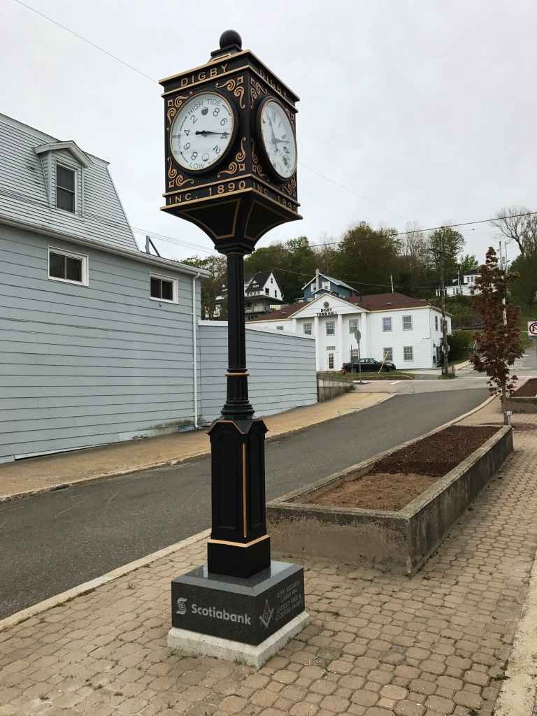
The clock below is both a conventional clock and a tide clock. The tide clock has one hand which moves in the usual clockwise direction. The 12 o'clock position is high tide and the 6 o'clock position is low tide. The clock below says that the tide is going out, and it is just over 4 hours to low tide:


Tides in Digby are typically about 25 feet and can exceed 30 feet. Later on our trip we'll see even higher tides elsewhere on the Bay of Fundy.

Sunday, May 21, 2017

Saint John, New Brunswick


Today we drove from Bangor, Maine (A) to Saint John, New Brunswick (B), a drive of just over three hours. The city of Saint John is on the southern edge of the province, where the 400 mile long Saint John River flows into the Bay of Fundy. (Click on any image to enlarge.)

The Bay of Fundy is famous for its high tides, and Saint John is known for the Reversing Falls on the Saint John River caused by those tides:


We did not see the Reversing Falls in action. The Saint John River was too swollen with water from snowmelt and spring rains for the usual effect.

The Reversing Falls occur in a short, narrow gorge and immediately upstream from the gorge. It is a significant tourist attraction, as can be inferred from the sign above. However, we were there before the tourist season had begun and no tourist attractions were open except the outdoor parks on either side of the river—Wolastoq Park and Fallsview Park. A restaurant on the gorge was under renovation; the photo above shows a construction trailer behind the sign.

Below is a view of the gorge from Wolastoq Park on the south side of the river. Spanning the gorge are a highway bridge on the right and a railway bridge to its left. The tourist sign, construction trailer and restaurant are visible at the near end of the highway bridge. The river flows from left to right in this photo:


When open, the restaurant at the Reversing Falls will include a skywalk. The photo below is looking up at the skywalk and restaurant from the south bank of the river:


Wolastoq Park is on a small hill on the south side of the river. Wolastoq (“the beautiful river”) was the name of the river in the language of the Native Americans. The park has great views and contains a dozen or more large wooden statues of figures that are significant in the history of Saint John.

One of the statues in Wolastoq Park is Samuel de Champlain, who in 1604 on his second voyage to the New World as a mapmaker for King Henry IV of France, sailed into the river (as far as the Reversing Falls) on June 24. That is the feast day of Saint John the Baptist, hence the current name of the river and the city. Below is the statue of Champlain:


Another statue in the park is Benedict Arnold, who lived in Saint John for a few years after he wore out his welcome in the American Colonies. He became disliked in Saint John as well, and left for England in 1791. Saint John was a popular city for refugee loyalists from the new United States following the American Revolution.

Wolastoq Park was created in 2004 and is maintained by J.D. Irving Limited, named for James Durgavel (J.D.) Irving, who started business with a sawmill in Bouctouche, NB in 1882. His son Kenneth Colin (K.C.) Irving (1899-1992) built the Irving companies into a formidable business empire. In 1998 Maclean's Magazine named K.C. Irving the most influential Canadian businessman of the 20th century. Below is the statue of K.C. Irving in Wolastoq Park:


Fallsview Park is on the other side of the river, a short ways upstream from the railway bridge. It is one of the best places to view the Reversing Falls. Directly across the river from Fallsview Park is Union Point which has been a site for various mills since the 1830s. The current mill is a pulp mill belonging to the Irving companies. Below is the mill from Wolastoq Park:


In colonial times, Britain and France fought bitterly over eastern Canada. Britain won control over all of Canada in 1763 at the conclusion of the Seven Years War (what we in the U.S. call the French and Indian War), but there remains a significant French influence in many parts of Canada. Both the English and French languages are used by the Canadian federal government, but most provinces privilege one language over the other. The province of Quebec privileges French. Most provinces privilege English. New Brunswick is the only one of the ten Canadian provinces to treat the French and English languages exactly equal. This was evident in all the signs we saw.

Saturday, May 20, 2017

Loggers Expo


The annual Northeastern Forest Products Equipment Exposition, usually called the Loggers Expo, was held in Bangor, Maine, on May 19-20. Paul and I attended today.

There was plenty of big equipment! Shown above is a John Deere 1270G wheeled harvester. Below are John Deere 853M and 853MH tracked feller bunchers/harvesters:


There were also plenty of displays of small equipment, even hand tools. Firewood is being made here:


In the photo above, note the grandstand in the background. It says “Bass Park Home of Bangor State Fair.” The other major building in the fair complex is the Cross Insurance Center, built in 2013. Below is a photo of exhibits inside the arena in the Cross Center:


In front of the Cross Center is a statue of Paul Bunyan, a fictional giant lumberjack who is significant in the folklore of the American timber industry:


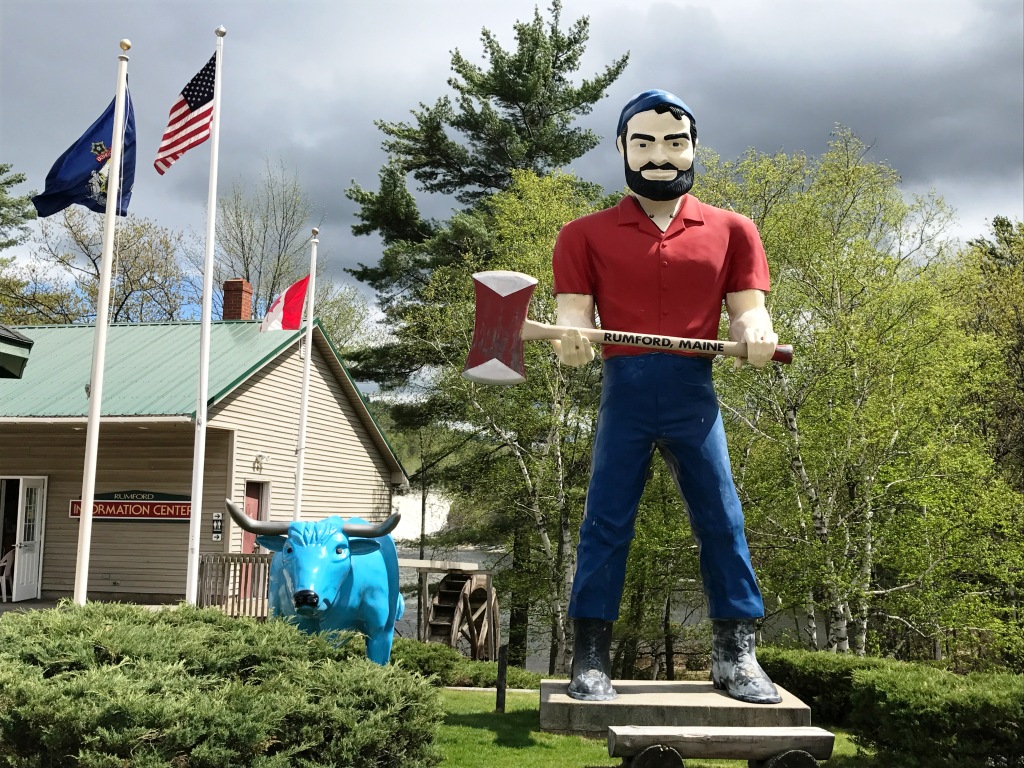
But this is not the only statue of Paul Bunyan in Maine! Rumford also has a statue of Paul, accompanied by Babe the Blue Ox:


I won't mention the fact that Michigan, Wisconsin and Minnesota also claim Paul and Babe as their own.

The Loggers Expo alternates between Bangor in odd years and the Champlain Valley Exposition in Essex Junction, Vermont, in even years. If you have a chance to go, it is worth the price of admission.

Monday, May 15, 2017

Maggie's Farm Urban Hike


Nancy and I participated in the Third Annual Maggie's Farm Urban Hike on Sunday, May 7. It was a wonderful adventure! The hike was in midtown Manhattan from the Lincoln Center to Greenwich Village. Bird Dog of the Maggie's Farm blog has photos and details here:

A few pics from the 3rd Annual Maggie's Urban Hike, with great pizza, beer, and cupcakes

I have little to add to Bird Dog's account. Nancy and I were visiting Emily in New Haven that weekend. We took the train from New Haven to Grand Central Terminal and walked from there to the Lincoln Center for the start of the hike. At the end of the hike we were part of a subgroup that walked from Greenwich Village back to Grand Central Terminal, and Nancy and I took the train back to New Haven. My Fitbit registered 28,662 steps for the day.

That day was also the day of the Five Boro Bike Tour in New York. Below is a photo of bicyclists that Nancy and I saw on the Avenue of the Americas (Sixth Avenue) on our walk from Grand Central Terminal to the Lincoln Center before the start of the hike:


I have only one photo from the hike of something not included in Bird Dog's excellent account – the smallest piece of private property in New York City, the Hess Triangle:


It was good weather for hiking, cool and overcast with no serious rain until the end of the day as we returned to Grand Central Terminal. The clock on the terminal in the photo below says 4:37 PM.


The photo at the top of this post is the World Trade Center from 6th Avenue and W 10th Street. That view brings to mind many thoughts, from September 11, 2001 to when I discovered blogs as a direct result of my first ever visit to New York City in April 2002. That story is here.