Wednesday, May 23, 2018
Bridges
Our destination on this vacation was Prince Edward Island. Not long ago PEI was reachable only by boat or airplane, but today we drove from New Brunswick to PEI across the Confederation Bridge, built in 1993-1997, shown above from the New Brunswick side. The eight-mile long Confederation Bridge (Wikipedia, homepage) is the longest bridge in the world that crosses ice-covered water.
Before I leave New Brunswick and start blogging about Prince Edward Island, there is more to be said about bridges. I was pleasantly surprised to learn that New Brunswick, like Vermont, has a rich heritage of wooden covered bridges. We visited three covered bridges near Alma, New Brunswick, on the Bay of Fundy, where we stayed for two nights.
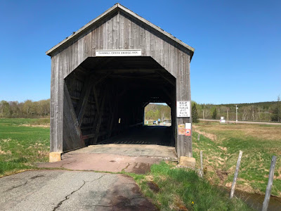
The bridge below is the Shepody River #3 covered bridge on Midway Road off Route 114 north of Alma:
The bridge below is the Sawmill Creek #5 covered bridge next to Route 114 north of Alma:
The bridge below is the Point Wolfe covered bridge in Fundy National Park west of Alma:
We drove through the Shepody River and Point Wolfe bridges. The Sawmill Creek bridge is no longer in service for automobiles, but is part of a trail system.
The Pointe Wolfe bridge is within sight of the Bay of Fundy, and the Point Wolfe River is a tidal river. This bridge must be one of the few wooden covered bridges in the world where salt water and fresh water mix under the bridge. From 1826 to 1921 there was an operating sawmill and dam adjacent to this bridge. These were removed following the establishment of Fundy National Park in 1948.
More information about covered bridges in New Brunswick: Government NB, Tourism NB, a personal blog, another personal blog.
Finally, I was interested to see a modern covered pedestrian bridge in Moncton, 50 miles north of Alma, albeit not a wooden covered bridge:
The bridge is over a tributary of the Petitcodiac River, and the red bank in the photo above is the bank of the Petitcodiac. The trail through the bridge is part of the Riverfront Trail, which in turn is part of The Great Trail (formerly called the Trans Canada Trail).
The map below shows the locations of the Confederation Bridge, Alma, and Moncton.
Subscribe to:
Post Comments (Atom)


No comments:
Post a Comment