Wednesday, May 23, 2018

Dalvay


Our first three nights on Prince Edward Island were in Dalvay, where we stayed at Dalvay By The Sea:


This historic property was built in 1895 as a summer home by Alexander MacDonald:
a wealthy businessman and one-time president of Standard Oil Company with John D. Rockefeller. He named the house “Dalvay By The Sea” after his boyhood home in Scotland.

Dalvay By The Sea is now a 25-room hotel in Prince Edward Island National Park and a national historic site.

We arrived on May 23 and went for a walk on Dalvay Beach:


It was 43°F, windy, and starting to rain. We did not stay on the beach for long.

The weather improved after that first day. The inn was a short walk from the ocean, visible over the dunes in this view on a later day from our second floor room:


Dalvay By The Sea reminded me of New England's historic "grand hotels." The accommodations were comfortable, especially the common areas, but the real treat was the food. Below was breakfast one morning – granola and yogurt, and French toast, both with fruit.


Prince Edward Island National Park includes several different sections along the north shore of PEI, with Dalvay about in the middle. We explored the park from our base here, as discussed in the next two posts. The park was not fully open for the season (no entrance fee!), and not all areas or attractions were open, but we were able to enjoy significant portions of the park. And we had the place almost to ourselves. It was clear that this is a popular park, and that there would be crowds of tourists later in the summer, especially since the Canadian government is currently upgrading many sections of the park. We saw many recent improvements, and considerable construction in progress.

Bridges


Our destination on this vacation was Prince Edward Island. Not long ago PEI was reachable only by boat or airplane, but today we drove from New Brunswick to PEI across the Confederation Bridge, built in 1993-1997, shown above from the New Brunswick side. The eight-mile long Confederation Bridge (Wikipedia, homepage) is the longest bridge in the world that crosses ice-covered water.

Before I leave New Brunswick and start blogging about Prince Edward Island, there is more to be said about bridges. I was pleasantly surprised to learn that New Brunswick, like Vermont, has a rich heritage of wooden covered bridges. We visited three covered bridges near Alma, New Brunswick, on the Bay of Fundy, where we stayed for two nights.

The bridge below is the Shepody River #3 covered bridge on Midway Road off Route 114 north of Alma:


The bridge below is the Sawmill Creek #5 covered bridge next to Route 114 north of Alma:


The bridge below is the Point Wolfe covered bridge in Fundy National Park west of Alma:


We drove through the Shepody River and Point Wolfe bridges. The Sawmill Creek bridge is no longer in service for automobiles, but is part of a trail system.

The Pointe Wolfe bridge is within sight of the Bay of Fundy, and the Point Wolfe River is a tidal river. This bridge must be one of the few wooden covered bridges in the world where salt water and fresh water mix under the bridge. From 1826 to 1921 there was an operating sawmill and dam adjacent to this bridge. These were removed following the establishment of Fundy National Park in 1948.

More information about covered bridges in New Brunswick: Government NB, Tourism NB, a personal blog, another personal blog.

Finally, I was interested to see a modern covered pedestrian bridge in Moncton, 50 miles north of Alma, albeit not a wooden covered bridge:


The bridge is over a tributary of the Petitcodiac River, and the red bank in the photo above is the bank of the Petitcodiac. The trail through the bridge is part of the Riverfront Trail, which in turn is part of The Great Trail (formerly called the Trans Canada Trail).

The map below shows the locations of the Confederation Bridge, Alma, and Moncton.


Tuesday, May 22, 2018

Hopewell Rocks


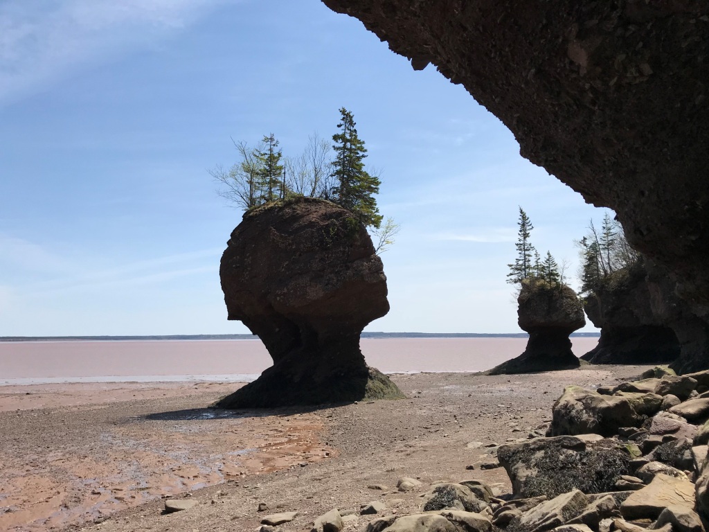
The Bay of Fundy between New Brunswick and Nova Scotia claims the highest tides in the world, exceeding 50 feet. The Hopewell Rocks are far up the bay on the New Brunswick side. These rock columns, also called the Flowerpot Rocks, were once part of the mainland but tidal erosion has worn away the shore. We visited the Hopewell Rocks today, and walked among the rocks at low tide.


The tide covers the base of the rock columns twice daily, and erosion is constant. Within the last few decades, existing columns have collapsed and new columns have formed.

We did not stay for high tide, when one can kayak between the rocks. The YouTube page for the Hopewell Rocks Provincial Park has several time-lapse videos of the rocks through an entire tide cycle. Follow the link for "Site Videos":

http://www.youtube.com/hopewellrocks1

As shown in the videos, the water in the upper Bay of Fundy is muddy. From a sign at the park:
The Bay's rich red mud flats are built up from an accumulation of silt carried by the tides from the sandstone cliffs. The sandstone contains iron that has been oxidized (exposed to air) which results in the brick red colour of the rocks. The Bay's famous chocolate-coloured water is the result of the constant movement of water over the Bay's mud flats, which does not allow the sediments to settle.

That sign was overlooking a mud flat just around the corner from the photos above. We also walked there while the tide was out:


From the same sign:
The mud flats that are seen from this viewing deck play an important part in the Bay of Fundy's diverse ecosystem. To the unsuspecting eye they are simply part of Fundy's unique and colorful landscape. However, to thousands of migrating shorebirds that visit the Hopewell Rocks each year, these mud flats are home to one of its most important inhabitants. Burrowed beneath the oozy, red mud are tiny mud shrimp that serve as food, and in turn, fuel for migrating shorebirds.

The migrating birds stop at Hopewell Rocks in mid-July to mid-August on their flight from the Artic to South America, so we were not there at the right time of year to see them (but we did see a pair of nesting peregrine falcons). Click here for more information about the migrating shorebirds.

The mud flat pictured above is called Demoiselles Beach. Also from the same sign:
The name 'Desmoiselles' refers to the cape, creek and beach in this area, and is attributed to early French explorers. Upon seeing the unique shapes of the rocks, with their distinctive flowerpot canopies, the French were reminded of shapely women wearing elaborate hats; thus the name 'Cap de Demoiselles' or 'Cape of Maidens'.

Sunday, April 22, 2018

Spring Day


Today was a beautiful spring day! The photo above shows Mount Mansfield, Smugglers Notch Ski Area, and the Lamoille River. The temperature reached the low 50s. I saw one farmer plowing his field next to the Lamoille River:


The two photos above were taken on River Road in Fletcher, near the town line with Cambridge.

Maple sugaring season is winding down. Below is Minor Family Maple in Fletcher:


The photo below shows Mount Mansfield just before sunset, from Bryce Road in Cambridge:


We had lost most of our snow earlier in April, and we thought spring had come! Then we got 3" of snow a week ago. That melted by mid-week, but on Thursday night we received another 2". It was a long week. The pleasant spring weather this weekend was most welcome.

Sunday, March 11, 2018

Butler Lodge


The ridgeline of Mount Mansfield extends two miles from the Chin in the north (Vermont's highest point at 4395') to the Forehead in the south (3940'). Butler Lodge is nestled in the woods south of and below the Forehead at 3030'. On a clear day, part of the ridgeline would be visible above and beyond the lodge in the photo above, but today was not a clear day.

Nancy and I snowshoed today from Stevensville to Butler Lodge via the Butler Lodge Trail on the Underhill side of Mount Mansfield. As we were leaving the parking lot, we met a party of seven or so snowshoers coming out, but otherwise we saw no one on the trail. There had been a fresh snowfall overnight of about 6", and we estimated 1.5-2.5' of snow in the woods depending on elevation. Fortunately the trail was well packed:


The Butler Lodge Trail is part of the Long Trail System. The Long Trail itself is on the ridge 0.1 miles above the lodge; we did not go that far. The Long Trail is blazed with white paint, which is sometimes hard to see in winter. Side trails are blazed with blue paint. The blazes on the Butler Lodge Trail must have been painted last fall. They were bright blue and easy to see.

But these are not the only trails in Vermont's woods, especially in winter. The Catamount Trail is a ski trail that, like the Long Trail, runs the length of Vermont. We did not encounter the Catamount Trail on today's snowshoe hike, because it is on the other side of Mount Mansfield (the Stowe side). But about halfway to Butler Lodge, we crossed a backcountry ski trail blazed with red plastic markers:


That red marker looked a lot like some of the markers we saw last month on the Madonna Vasa Trail! Indeed, the map at the Stevensville trailhead revealed an extensive network of backcountry ski trails. (But not the Madonna Vasa Trail.) On the map, the ski trail we crossed was labeled "W.B. Trail" north of the Butler Lodge Trail and "Underhill/WB" to the south.

North of the Butler Lodge Trail, the W.B. Trail crosses the Frost and Tear Drop Trails and continues to Underhill State Park. South of the Butler Lodge Trail it connects to the Underhill and Overland Trails which lead over the ridge to Stowe where the map showed even more backcountry ski trails. (The W.B., Tear Drop, Underhill and Overland Trails are all backcountry ski trails. The Butler Lodge and Frost Trails are hiking trails in the Long Trail System.)

I learned a lot from the map at the Stevensville trailhead that I didn't know before. In addition to those backcountry ski trails, I learned about the website www.trailfinder.info about trails in Vermont and New Hampshire. The main organization behind the website is the Upper Valley Trails Alliance headquartered in Norwich, Vermont, which I had not heard of before. There's a lot going on in the backcountry of Vermont!

Stats for today's hike: Distance – 1.8 miles each way. Elevation – 1400' at the trailhead and 3030' at the lodge for a gain of 1630'. Temperature was in the upper 20s.

Saturday, February 17, 2018

Madonna Vasa Trail


Today we snowshoed a section of the Madonna Vasa Trail. It was a beautiful day!


Our party of six snowshoed from Smugglers Notch Ski Area to Iron Gate Road, a distance of perhaps five miles. There was about a foot of snow on the ground in most places, less here than on our hike a few days ago on Laraway Mountain. A fresh snowfall of 2" overnight made for pleasant snowshoeing. When we started it was clear and sunny, about 20 degrees F. By the time we finished, it had become cloudy and warmed up to 30 degrees F.

We saw several old cellar holes, signs of civilization past:


And we saw signs of civilization present: a logging operation and three maple sugaring operations. The photo below is a typical pipeline system for collecting sap from sugar maple trees:


The box on the tree in the photo above is a solar powered Tap Track wireless vacuum monitoring system. Maple sap pipelines are on vacuum, and they work best when there are no leaks. The Tap Track system helps the sugarbush operator identify the location of leaks.

The Madonna Vasa Trail was built in the early 1960s for cross-country skiing. The full trail extended about 14 miles along the side of Mount Mansfield, Vermont's highest mountain, from Smugglers Notch Ski Area in Cambridge to Mountain Road in Underhill (the road to Underhill State Park). There were cross-country ski races on the Madonna Vasa Trail in most years 1967-1975, as snow conditions permitted, but use of the trail declined after that.

Nevertheless, we found several kinds of trail markers in the woods. The tree below had three kinds of markers: rectangular metal, faded plastic diamond, and newer plastic diamond.


The tree below had a plastic diamond indicating that the trail turned right, plus a plastic circle:


We also saw round metal markers:


The Madonna Vasa Trail was named after Madonna Mountain (one of the mountains in Smugglers Notch Ski Area) and the Vasaloppet – a famous cross-country ski race in Sweden inspired by a legendary ski run in 1520 by Gustav Vasa, later King Gustav I and considered the founder of modern Sweden. "Vasaloppet" is Swedish for "Vasa race."

Thanks to Joel Page for organizing today's adventure. Most of us on today's outing had snowshoed a portion of today's trek in 2012, also led by Joel.

Tuesday, February 13, 2018

Laraway Mountain


The Long Trail on Laraway Mountain goes under south-facing cliffs which form impressive ice columns in the winter!


Just above those cliffs is a lookout. The mountains on the horizon to the right of the tree in the second photo below are Whiteface, Madonna and Mount Mansfield.


Laraway Mountain is in Waterville, Vermont. Today Joel, Nancy and I snowshoed the Long Trail from Codding Hollow to the lookout on Laraway Mountain, about two miles each way. It was a sunny day with light winds and temps in the low 20s. There was about two feet of snow in the woods, much more than at home, but we did not have to break trail. The trail was well packed, although we saw no one.

At the lookout we saw a dozen or so ravens having fun in the sky. (I took photos, but failed to get a good one.) We could see Lake Champlain and the Adirondack Mountains of New York on the far side of the lake. It was a beautiful day.

Below is another photo of the ice formations on our way down from the lookout:


The best day in winter is better than the best day in summer! (I've said that before.)

Monday, January 8, 2018

Backcountry Recreation, Part 1


Backcountry recreation is growing in popularity in my town of Cambridge, Vermont, and in northern New England generally. By "backcountry" I mean off-road, not necessarily deep wilderness. The photo above was taken yesterday in a field at the West Farm in Cambridge, owned by the Brewster Uplands Conservation Trust, which in turn is owned by the Vermont Land Trust. The farm property includes seven miles of multi-use trails open to the public. Mount Mansfield, Vermont's highest mountain, is in the background.

Winter backcountry recreation in Cambridge includes Alpine and Nordic skiing as well as snowboarding and snowshoeing at Smugglers' Notch Resort, snowmobiling on the Lamoille Valley Rail Trail, snowshoeing on the Long Trail (or almost anywhere), and all of the above (plus sledding!) on the state highway through Smugglers' Notch, which is not plowed in winter. Smugglers' Notch, with 1000' cliffs on both sides, is popular in winter with ice climbers.

Smugglers' Notch Resort is a four-season resort, and the scenic road through Smugglers' Notch is popular in spring and summer and especially during fall foliage season. Other summer backcountry recreation in Cambridge includes hiking on a wide variety of trails, bicycling of all kinds, and paddling on the Lamoille River. All of these activities, in all seasons, have increased in recent years.

I have been interested and a little surprised to learn about so many organizations that exist to support backcountry recreation all across Vermont and northern New England. In addition to the organizations linked above, here are a few more that I recently came across:
No doubt there are many more, but this gives you an idea of the breadth and depth of organizations out there.

It should not be surprising that Vermont is a leader in backcountry recreation. The concept of long distance hiking has deep roots in Vermont, with the creation of the Green Mountain Club and the Long Trail in 1910, which in turn inspired the Appalachian Trail. Regular readers of this blog may recall that Nancy and I spent several days on the Long Trail in 2017 (details here).

In fact the concept of long distance hiking in Vermont goes back nearly a century before the creation of the Long Trail to one Alden Partridge (1785-1854). The link is to an article about Partridge by Vermont historian Mark Bushnell. Partridge was a native of Norwich, Vermont. He attended nearby Dartmouth College before transferring to West Point. In 1819 he founded what is now Norwich University, the oldest private military academy in the United States. The school was originally in Norwich, hence the name, but it has been in Northfield since 1866. Partridge's backcountry hiking exploits were legendary, as described in Mark Bushnell's fascinating article which includes an account of a bushwhack ascent of Mount Mansfield in 1818, the year before Partridge founded Norwich University.

Today the town of Norwich (about the size of Cambridge) is still making news, as noted in this New York Times article last month: A Tiny Vermont Town Is a Big Cradle of Olympians (subscription probably required, sorry). But that's merely the Olympics. In this post I am interested, like Norwich's native son Alden Partridge, in backcountry – and I am proud to say that Cambridge is the home of Backcountry magazine.

Backcountry recreation draws visitors. Last summer the men's and women's cross country running teams from West Point visited Cambridge to train on the Lamoille Valley Rail Trail and other trails. All this interest in backcountry recreation is exciting for Cambridge!

So, I am part of Cambridge town government. What are the implications here for government? That is a topic for my other blog, The Switchel Philosopher.

See Backcountry Recreation, Part 2.

Monday, January 1, 2018

The Switchel Traveler


Today I am renaming this blog to "The Switchel Traveler."

Henceforth my two blogs are:
"The Switchel Philosopher" is for adventures in the world of ideas. The tag line is:

What is a proper relationship between a free people and their government?

"The Switchel Traveler" is for travel adventures in the physical world. The tag line is:

There are more things in heaven and Earth, Horatio, than are dreamt of in your philosophy.

The tag line for "The Switchel Philosopher" is meant to serve as a muse for that blog, where a frequent topic is government and citizenship. The tag line for "The Switchel Traveler" is Hamlet's reminder that we can never know everything. Philosophy alone is not enough; we also need to explore the world.

Why switchel? Because I like it! Also because switchel has a yin and yang aspect to it, and much of life is like that. Even my two blogs have a yin and yang aspect, with one about the physical world and the other about the world of ideas.

Switchel is a non-alcoholic beverage dating back to Colonial times. My mother made switchel for our family when I was growing up on the farm, and we drank a lot of it in the hayfield.

The main ingredients in switchel are sugar, vinegar, ginger and water. The sweet and sour of sugar and vinegar are the yin and yang of switchel. In my part of the world (Vermont), the sugar is usually maple syrup and the vinegar is almost always apple cider vinegar. But variations are allowed. Honey and pomegranate vinegar are also good. Sometimes additional ingredients are added such as lemon juice (or even rum!). Today, commercial versions of switchel are available, for example Vermont Switchel and Up Mountain Switchel.

Oh, another thing about switchel. The ginger tends to settle out, so you have to shake it before drinking. Sometimes life is like that, too.

My blogging history

"The Switchel Philosopher" is my most recent blog. I started it in February 2017, after retiring in December 2016. It is about adventures in the world of ideas, including government and citizenship. Being elected to the town selectboard in March 2017 has contributed to some of the themes on this blog.

"The Switchel Traveler" – this blog – is an older blog and has had two previous names. I started the blog in 2007 as "George's Home Blog" to distinguish it from my "work blog" which I also started in 2007. After retiring, the work/home distinction was not applicable any more, and I renamed this blog to "George's Other Blog" to distinguish it from "The Switchel Philosopher." Today I am renaming it again, this time to "The Switchel Traveler" to more clearly indicate how my two personal blogs complement each other.

Post retirement, my two personal blogs have different and distinctive themes:
  • The Switchel Philosopher – adventures in the world of ideas
  • The Switchel Traveler – travel adventures in the physical world
Prior to retirement, I blogged about both themes on both my "work blog" and my "home blog." Examples of both themes on my "work blog" included Trip to China and Values. My "home blog" has always included travel adventures. Prior to retirement it also included adventures in the world of ideas, some of which are captured by the labels culture, money, reality and slow.

There are also some earlier adventures in the world of ideas on "George's VAFPDB Blog." I published ten posts there in 2012-13 before resigning from the Vermont Agricultural and Forest Products Development Board.

Sunday, December 31, 2017

Blog Recap 2017


After retiring in December 2016, this blog became my home for writing about travel adventures. Below is a summary of my 2017 posts here.

We started the year with brunch with family and friends followed by a snowshoe hike:
In January and February we drove to Florida for a 3 week road trip. I wrote 21 posts about that trip, which you can find in:
After returning home, I blogged about three small adventures in late winter and early spring:
In May we had an adventure right at home!
Also in May we took a trip to Connecticut and New York City, with a stop in Massachusetts on the way home:
In May and June we took a 2 week road trip Nova Scotia by way of Maine and New Brunswick. We had a great time, but I didn't do well at blogging that trip. Only three posts:
Other places in Nova Scotia we visited: the Annapolis Valley, Wolfville (The Blomidon Inn), Grand-PrĂ© National Historic Site, Halifax, the Cabot Trail in Cape Breton Highlands National Park, Ingonish (Keltic Lodge), Sydney, the Fortress of Louisbourg, Parrsboro (The Maple Inn), Cape D'Or. We saw a tidal bore in Truro – a first for me. We also spent a night in Moncton, New Brunswick, on the way home. It was a delightful trip.

When Nancy and I retired, she had about 50 miles left to complete the Long Trail. We hiked those miles together, in four day hikes in July, August and September. I had fun both hiking and blogging about it, including interesting things we learned along the way:
I finished the year with posts about three small adventures:
There were several travel adventures in 2017 that didn't get blogged: seeing the Tall Ships in Boston in June; an "escape room" on a different trip to Boston; Minute Man National Historic Park; hikes up Mount Mansfield, Snake Mountain and Laraway Mountain; numerous other small hikes; the Tunbridge World's Fair; two outings to Huntington River Vineyard for their Sunday Supper Dinner Series; a visit to Ayers Brook Goat Farm; a "Happily Ever After Party" in October on the coast of Maine (Kelly and Scott); and other trips to Maine to visit family. A pretty good year!

I write on two blogs. This blog, The Switchel Traveler, is for travel adventures in the physical world. My other blog, The Switchel Philosopher, is for adventures in the world of ideas. See my About page for more information about switchel, me, my two blogs, and my blogging history.

Sunday, December 24, 2017

Milton Pond


Milton Pond lies within the Milton Town Forest. The photo above shows the outlet of this 33 acre pond, which used to be part of the municipal water supply for the town of Milton, Vermont.

We had celebrated Thanksgiving by hiking around ponds in Massachusetts, and today we continued that practice in Vermont for the Christmas holiday by hiking around Milton Pond. This time we had 6" of snow on the ground, as compared to bare ground at Thanksgiving. We were joined by friends including Kona the dog:


There are several trails in the Milton Town Forest. Our hike around the pond today was 3.75 miles. We did not use snowshoes. The following map is from the link in the first sentence above:


We met Brian Pease who lives next to the Milton Town Forest and works on the trails. Northern Vermont experienced a powerful windstorm two months ago, on the night of October 29-30, and Brian talked about cutting up and clearing more than 100 trees that had fallen across the trails during that storm. We appreciated his hard work!

Monday, November 27, 2017

Walden Pond and Fresh Pond


I went to the woods because I wished to live deliberately, to front only the essential facts of life, and see if I could not learn what it had to teach, and not, when I came to die, discover that I had not lived.

Henry David Thoreau wrote those words in Walden; or, Life in the Woods about living in a small cabin near Walden Pond in Concord, Mass. The photo above was taken from where his cabin was located. Walden Pond is visible through the trees.

It was a small cabin, only 10'x15', which Thoreau built himself. He lived there for two years, two months, and two days – from just before his 28th birthday in 1845 to just after his 30th birthday in 1847. (Thoreau only lived to age 44.)

We visited Walden Pond State Reservation over the Thanksgiving holiday. Thoreau's original cabin no longer exists, but a replica stands near the park entrance, along with a statue of Thoreau:


Below is a better photo of the statue:


Our timing was fortunate. There is considerable interest in Henry David Thoreau this year, the 200th anniversary of his birth. The park features a new (2016) visitor center with informative exhibits, a gift shop well stocked with books, and a very new* Ken Burns documentary film. You can watch the film at the link.

*The film premiered at Boston College on November 8, 2017.

We celebrated Thanksgiving this year in Cambridge, MA instead of Cambridge, VT. There is another notable pond in Cambridge, MA – Fresh Pond, part of the municipal water system for Cambridge. The photo below is Fresh Pond at dusk, with a sliver of a new moon reflected in the water.


Fresh Pond and Walden Pond are about 12 miles apart. Both ponds are heavily visited by the public, but they are quite different. Walden Pond retains its rural character, while Fresh Pond is surrounded by development. One can swim and fish at Walden Pond, but not at Fresh Pond. On the other hand, no pets are allowed at Walden Pond, while dogs are numerous on the path around Fresh Pond.

In the photo below, the building is the Cambridge Water Department on the edge of Fresh Pond. The sign says "Envision Cambridge" and the bicycles are part of Hubway.


We walked around a pond every day this Thanksgiving weekend, either Fresh Pond or Walden Pond.