How did we get around in Washington? Mostly by walking. Washington is a great city for walking. It is mainly flat, sidewalks are wide, and around much of the National Mall one has a choice of walking on pavement, gravel, or grass.
Walking was enjoyable. The architecture and landscapes are interesting everywhere one turns. And there are no skyscrapers. The "feel" of the city for a pedestrian is much more enjoyable than a city with tall skyscrapers.
Distances are considerable, however. There is a lot of walking to be done. Consider the triangle formed by the Capitol Building, the Washington Monument, and the White House:
- the Washington Monument is 1.4 miles west of the Capitol
- the White House is 0.6 miles north of the Washington Monument
- the White House is 1.6 miles west-northwest of the Capitol
Sometimes we rode the free "Circulator" bus which has several routes that are useful for tourists.
Streets are laid out simply. Lettered streets run east and west. Numbered streets run north and south. Sequencing begins at the Capitol Building in all directions. In other words, there are two I Streets – one north of the Capitol and one south of the Capitol, and there are two 8th Streets – east and west of the Capitol. It is important to keep in mind the four quadrants centered on the Capitol. (The satellite photo here may help to visualize the city and the four quadrants.) 8th and I Streets SE is Marine Barracks, while 8th and I Streets NW is in Chinatown.
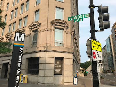
Avenues named after states run at an angle. For example, Vermont Avenue (see the photo above) runs north-northeast from Lafayette Park near the White House, while Pennsylvania Avenue runs diagonally between the Capitol and the White House (and beyond in both directions). The address of the White House is 1600 Pennsylvania Avenue NW (i.e., 1.6 miles from the Capitol).
Electric scooters have become popular in recent years in some cities. There were many scooters of various brands in Washington. We tried them out on a Sunday morning when there were fewer people out and about. (There are countless school groups in Washington at this time of year.) We rode scooters from near our hotel to the Lincoln Memorial, stopping for pictures:
That trip was 2.3 miles and it took us 36 minutes (with stops). Top speed on the scooters was 15 mph.
In the photos above, the Reflecting Pool between the Lincoln Memorial and the World War II Memorial was dry. We did not learn why.
We flew from Vermont to Washington. At no time after leaving Vermont were we in a car. We did not rent a car (parking rates at the hotel were high), nor did we ever take a taxi or Uber. Plenty of other people, however, were on the roads which were congested with cars and tour buses.
For us, walking – with occasional use of public transit and one time on electric scooters just for fun – was perfectly satisfactory for getting around in Washington as a tourist at this time of year.
Washington, DC Trip: Click here for the introductory post about our trip to Washington which lists all of the posts in this series.


No comments:
Post a Comment